


Thoughts on the proposed Quarry Heights development
On the housing shortage, lot sizes, car-centric development, property taxes, and why the city doesn't just turn it into a park.

Several people have asked me about the proposed Quarry Heights development at the old Frazier Quarry behind the Food Maxx shopping center on West Market Street. The Harrisonburg Planning Commission has already voted unanimously to recommend approval to City Council, so my opinion is already a matter of public record. But it’s worth digging into the details of why I voted to approve. To state the obvious, I’m speaking for myself here, not other planning commissioners or Community Development staff.

The Quarry Heights proposal is big: 953 new housing units on 161 acres on the west side of town. The only other recent development approaching this scale is Bluestone Town Center, the 897-unit affordable housing project on 89 acres near the corner of Erickson and Garbers Church Road. The actual buildable acreage at the quarry site is significantly reduced due to the massive hole in the middle of it. The quarry itself may eventually become a reservoir that Public Utilities would use for water storage — an incredibly valuable asset for the city — but the water storage element is not part of this particular rezoning request.

The first question one should ask about any rezoning request is: what can the property owner do with the land by right (if the request gets denied)? By right use means: what the owner of the property can do with/on the land without a rezoning. In this case, the majority of the land is zoned M-1 (industrial), the westernmost parcel is zoned R-2 (residential), and a smaller portion is zoned B-2 (business). The comp plan land use guide designates this site as general industrial, low-density mixed residential, and medium-density mixed residential. (It’s confusing, but the land use guide and the zoning map are separate).

Without seeking permission from the city for a land use change, this site could legally be a poultry plant, a factory, a manufacturing plant, a storage facility, a warehouse, a gas station, or any of at least a dozen other industrial uses. The by-right use is the baseline we should compare to the proposal. Does the city need what the applicant is proposing more than we need (in this case) industrial buildings? The answer depends on several factors.
Addressing (part of) the housing shortage
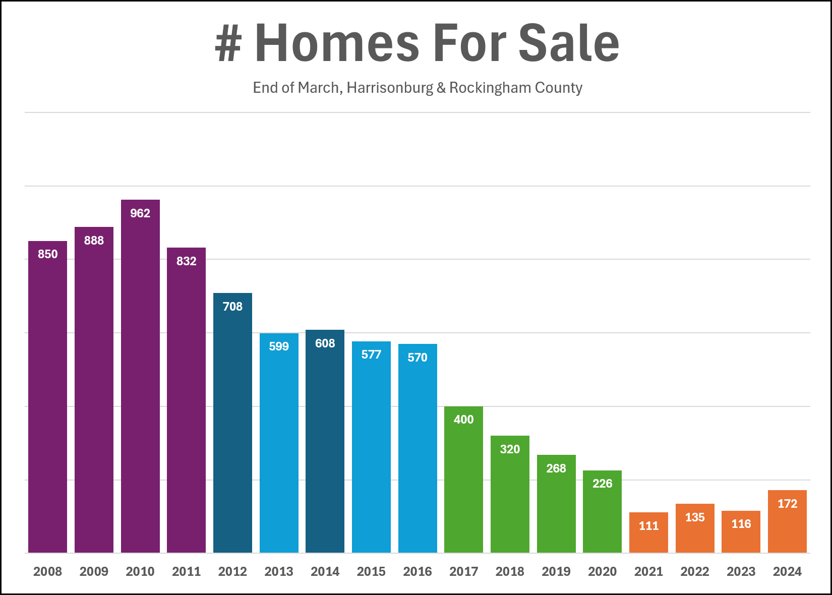
I’ve written about the housing shortage here and elsewhere. I won’t rehash all the reasons Harrisonburg needs more housing, but suffice it to say we have a shortage of all types of housing in the city. Scott Rogers has been tracking local realty data for decades. Here’s a graph he made that helps to illustrate the decline in available homes for sale in the month of March from 2008 through earlier this year. Keep in mind, this is Harrisonburg and Rockingham County combined:
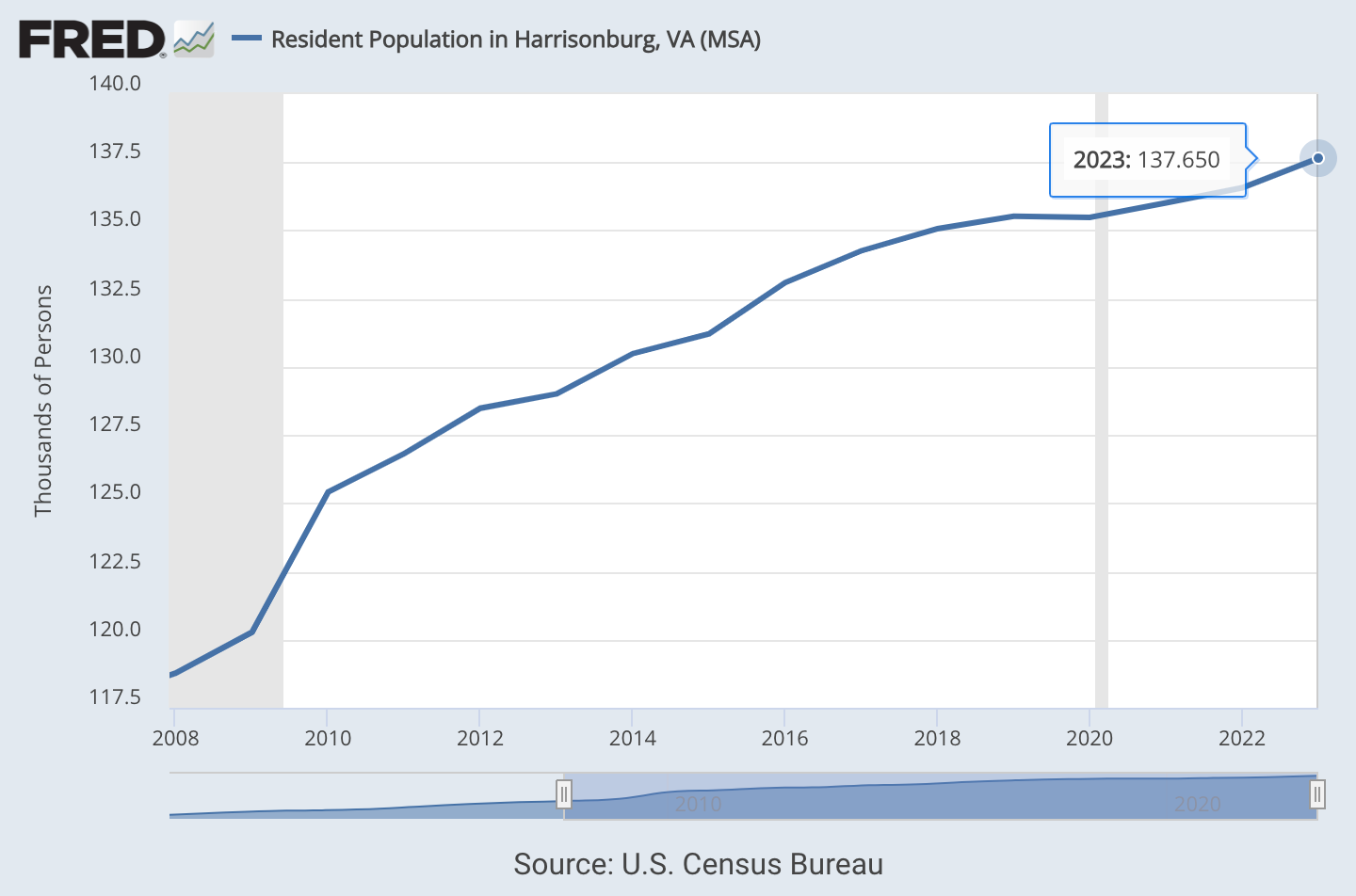
And here’s a graph showing the population growth in the Harrisonburg MSA (city and county combined) over that same period. As you can see, the charts are moving in opposite directions. That’s a problem for obvious reasons.
The apartments, townhomes, and single-family detached houses (SFDH) in the Quarry Heights plan are not “affordable” in the government subsidy sense of the word. They are unsubsidized market rate units that meet a need in “Market Type A,” identified in the 2021 housing study as having “above median overall access to amenities such as public transit within walking distance, full-service grocery stores, and multiple parks and recreation facilities.”
I would like to have seen an effort from the developer to partner with a local affordable housing organization like Habitat for Humanity or HRHA to build some subsidized affordable units. But subsidized units are not part of this proposal. By increasing density and keeping the lot sizes small, one could argue that these units would be “market rate affordable” when compared to the low-density R-1 new construction. The Quarry Heights plan shows 653 townhouses or “villa style units” and 48 small-lot (R-8) SFDH that would be for sale. Overall, about 72% of the units would be for sale. In addition to units that would be sold individually on the market, plans show 264 apartment units for rent (about 28% of the total 953 proposed housing units).

The developer estimates that the prices for the townhomes would likely be comparable to newly-constructed townhomes at Preston Lake. Those are currently selling in the ballpark of $320K to $560K. How could anyone consider that affordable? A good follow-up question would be: if this site were to be developed entirely as low-density, large lot SFDH, how much would those homes cost? Based on similar large lot newly-constructed houses for sale in our MSA, my guess would be somewhere between $700,000 and $1.6 million per house (there’s a SFDH in Belmont, not far from this site listing for $812K). In other words, these homes are more affordable than they would be if this site were to be developed as low-density SFDH on large lots.
A step away from car-centric development
One of the primary concerns about new housing developments we often hear from nearby homeowners is how much more car traffic it could add into the surrounding neighborhoods. That’s a concern that I share. Urbanists and homeowners who oppose new multifamily housing developments might not agree on upzoning, but I think we can agree that we don’t want more cars speeding through our neighborhoods and clogging up our streets.
This development will very likely contribute to more car traffic in the city. Unfortunately the city still has mandated off-street parking requirements in place which undermine public transit goals and make walkability and car traffic worse. It’s true that Quarry Heights has a lot of car storage spaces in the plan. However, I believe the developer has made a good faith effort to promote walking and biking: raised crosswalks, modal filters to block car traffic from College and Hillside, 20MPH speed limits on the private streets, a pedestrian connection to the back corner of the Food Maxx shopping center, and a network of publicly-accessible shared use paths. In my experience using an ebike as my primary mode of local transportation for the past two years, there are several areas in the city where safe biking and walking routes simply disappear, and there are few (or no) good alternate routes to get where I’m trying to go. The quarry is one of those areas.
The Strava heat maps for biking, walking, and running are not comprehensive — not everyone who runs, walks or rides a bike uses Strava — but it gives us some idea of how and where people are using streets and trails. For example, there are some “digital desire paths” — unofficial shortcuts that don’t appear on Google Maps — that show up on Strava. Heavily-foot-trafficked routes show up as dark lines, depending on how often app users travel there. This heat map shows a lack of connectivity between Greystone and West Market Street — Strava users reach the end of College or Hillside and turn around.

There’s a middle school and a heavily-used bike-walk trail on the south side of 33, and virtually no routes in-between. In it’s current configuration, Waterman Drive is terrible for walking and biking. If the Quarry Heights development gets built, these gaps would be filled in with shared-use paths. These publicly accessible 10-foot wide paved pathways, separated from car traffic, would allow more local residents options to safely and comfortably get around without a car. A Strava heat map with these proposed trails integrated might look something like this:

It will be critical for the city to build safe crossings to get to the south side of 33. The crosswalk on Neff Ave. between the Sunchase apartments and the JMU arboretum is an example of an unsafe crossing. We’ll need to do better here if we want to encourage alternate modes of transportation.
Municipal tax revenue
In the US we have an absurd property tax system where we tax the structures (i.e. the improvements on the land) rather than the value of the land itself. A much more sensible system would be a land value tax (LVT) that would incentivize property improvements, rather than effectively penalizing them. An LVT would disincentivize low-density underutilization of privately-owned land in cities. But Harrisonburg doesn’t have the authority to implement an LVT without special permission from the state legislature.
I mention LVT because it’s important to understand what tax revenue these parcels around the quarry currently contribute, so we can compare that to what they could contribute if redeveloped as proposed. Here’s a 3D map of Harrisonburg created by geoaccounting expert Joshua McCarty, showing value-per-acre. We see a spike in land value downtown, while the quarry site is virtually flat.

The site is comprised of five separate parcels on the tax map. When I added up the combined assessed value of all five parcels, I got $4,188,000 for all 161 acres (check my math and correct me if I’m wrong here). The economic impact analysis submitted by the applicant estimates this development will have a tax value of $328,150,000. That’s more than 78 times the current assessed value, an increase of more than seven thousand percent.

I’ve heard concerns about new housing increasing student enrollment in city public schools. While I believe funding schools with local property taxes is a bad system, it’s the system we have, and I’m not aware of viable funding alternatives available to municipalities in a Dillon Rule state. Schools account for 30 percent of Harrisonburg’s annual budget, and property taxes make up 37 percent of the city’s revenue. The tax revenue from the quarry development would help fund our school budget. There are three schools on the west side of town: Bluestone, THMS, and HHS. Considering that there is another large affordable housing development underway (also on the west side of the city) Quarry Heights appears to be well-placed in terms of keeping our school districts from becoming too income-segregated.
Why doesn’t the city turn it into a park?
We’re bound to lose some tree canopy cover in the process of grading and development. This was a common concern among many of the homeowners who spoke at the Planning Commission meeting last month. Why can’t the city turn this into a park or a nature preserve? The short answer to that question is: it’s private property. It’s the same reason the city doesn’t turn your house into a park. Also, compared to the east and south sides of the city, the west side of town has plenty of parks: Westover, Hillandale, and a 191-acre municipal golf course — 191 acres that I believe can and should be put to a higher use.
I share the concern of neighbors about the loss of tree canopy cover, and also acknowledge that trees at this site may get cut down even if this request is denied by Council. Should the city attempt to buy the property and turn it into a nature preserve? Not in my opinion. Should the city add tree canopy requirements to new development sites? Yes, but only if we remove the parking requirements first.

Despite how it might appear to an outside observer, city planners don’t get to decide who files requests, what types of developments those requests are for, or the location of the requested developments. Community Development staff works with the applicants to address a myriad of city concerns before the request comes to the Planning Commission. Occasionally staff will recommend denial of a request. In this case, staff recommended approval. For better or for worse, the only thing planning commissioners can do is vote yes or no or table the request, and suggest conditions for City Council to consider.
After hearing concerns from the neighboring homeowners, commissioners did consider adding a suggested condition to provide more of a buffer zone along the upper northwestern side of the quarry development . However, because the proposed layout has a street (not a building) along the northwestern edge of the development, Planning Commission had no authority to condition the recommendation with something like “the setback from the road to the property line along the northern edge shall be X feet.” Do you find the street-vs-building setback distinction confusing or ridiculous? I certainly do.
I’m often faced with a decision to vote for something I don’t like or something that I think would be even worse. This was not one of those requests. Although I believe the Quarry Heights plan is missing mixed-use and subsidized housing elements, I still think the positives outweigh the negatives. City Council is scheduled hold a public hearing on this rezoning request Tuesday, November 26. I support the right of neighboring residents to advocate for their concerns to be addressed, and I also support the less car-centric direction this plan has taken. In my opinion, this would be a net positive development for the city.